I spend a lot of time looking at historic and current maps and aerial imagery for my job and during my personal time. Over the past several months I've been taking the dog out and finding and photographing benchmarks. While looking at topo maps for new benchmarks to visit, I found a point that was labeled "beacon". I did a bit of searching on the internet and came across a few sites that described what the beacon on the map was. The following description was taken directly from this site: https://wchsutah.org/aviation/navigation-arrows.php
“On August 20, 1920,
the United States opened its first coast-to-coast airmail delivery route, just
60 years after the Pony Express closed up shop.
There were no good aviation charts in those days, so pilots had to eyeball
their way across the country using landmarks. This meant that flying in bad
weather was difficult, and night flying was just about impossible.
The Postal Service solved the problem with the world's first ground-based
civilian navigation system: a series of lighted beacons that would extend from
New York to San Francisco. Every ten miles, pilots would pass a 70-foot
concrete arrow on the ground which was painted a bright yellow. At the center
of each arrow there would be a 51-foot steel tower and topped by a
million-candlepower rotating beacon. Below the rotating light were two course
lights pointing forward and backward along the arrow. The course lights flashed
a code to identify the beacon's number. If needed, a generator shed at the tail
(or feather end) of each arrow powered the beacon and lights.
By 1924, just a year after Congress funded it, the line of giant concrete
markers stretched from Rock Springs, Wyoming to Cleveland, Ohio. The next summer, it
reached all the way to New York and then extended all the way to San
Francisco by 1929.
Around 1926, the new Aeronautics Branch in the Department of Commerce (or U.S.
Postal Service?) proposed a 650-mile air mail route linking Los Angeles to Salt
Lake City and passing through Washington County. It was designated as Contract
Air Mail Route 4 (CAM-4).
Western Air Express, Inc. was awarded a contract to lay out the route and carry
the mail. Their first flight was made on April 17, 1926 in a Douglas M-2
airplane. By 1928, the route had been marked with the cement arrows and beacon
towers for navigation at night and in inclement weather.
New advances in communication and navigation technology made the big arrows
obsolete, and the Commerce Department decommissioned the beacons in the 1940s.
The steel towers were torn down and went to the war effort. Today, only some of
the weathered cement arrows (less the yellow paint) remain.”

 |
Portion of the 1932 Prescott Airway map. Beacon sites are shown as red stars.
|
I decided to go visit the "beacon" site that I'd found on the topo map. I couldn't see anything on Google Earth to indicate that any tower or structure were ever existed. Sure enough, I didn't find anything at the site; not a single thumbnail size piece of concrete, metal or glass.
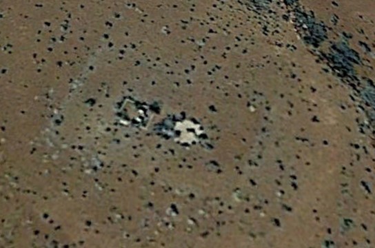
I decided to try and pinpoint the location of beacon sites 42 and 43B. A few minutes of looking at Google Earth revealed that there were very visible remains of both sites. I drove out to site 42 which is located south of Winona and less than 100 meters from a Forest Service road. The concrete arrow is no longer in place. Roughly 60 m from the concrete foundations is an area of metal scraps that appear to be pieces of the generator building.
 |
Remains of beacon site 42 on a Google Earth screen capture.
|
 |
| Rock outline that is around the concrete foundations. It doesn't show up well on the Google Earth image. |
 |
Thick piece of glass that may be part of the beacon.
|
Beacon site 42A was located at the Winona Intermediate Field (see http://www.members.tripod.com/airfields_freeman/AZ/Airfields_AZ_N.htm for a discussion of this site). I was aware of this airstrip and have looked at it on several older dates of aerial imagery. The three landing strips can still be faintly made out. There aren't any visible remains of the beacon tower or shed. This is located on private land so I've not walked the site.
 |
Winona Intermediate Field - 1997
|
 |
Winona Intermediate Field -2017
Beacon site 43B is accessed on the Buffalo Range Road exit on Interstate 40. It is located on private land (you need to sign-in and display a pass) and requires a vehicle with high clearance to reach it.
|
 |
It appears that portions of this have been used for target practice.
|
 |
Small piece of galvanized steel that may have been part of the beacon tower.
 | Beacon site 45. This site is located north of Meteor Crater. I've not visited this site.
I've located several other sites in the Holbrook area using Google Earth. They appear to be in very similar shape to those I've visited on the ground. |
|


No comments:
Post a Comment